1/5


MTB Project
1K+다운로드
16MB크기
25.4.0(25-01-2025)최신 버전
세부 정보리뷰버전정보
1/5
MTB Project의 설명
MTB 프로젝트는 당신이 어디에 있든 당신이 타고 싶은 트레일에 대한 포괄적 인 가이드입니다.
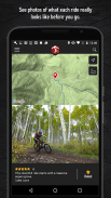
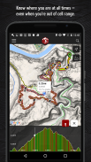
인쇄 된지도의 철저 함을 통해 전체 GPS 경로 정보, 고도 프로파일, 대화 형 기능, 사진 등을 제공합니다. 가이드 북과 마찬가지로, 현재 위치 근처 나 검색 한 지역에서 최고의 추천 놀이기구를 추천합니다. 현지 전문가가 멋진 라이딩을 계획하는 데 필요한 하이라이트, 도전적인 기능 및 통찰력을 보여줍니다.
• 승무원과 파쇄 할 77,000 마일 이상의 트레일을 찾으십시오.
• 엄청나게 상세한 산악 자전거 트레일 및 라이드 데이터베이스에 새로운 라이드와 트레일이 지속적으로 추가됩니다.
• 정확한 위치는 트레일에 표시됩니다.
• 그리드에서 벗어난 경우 다운로드 된 트레일이 오프라인으로 작동합니다. (셀 수신 불필요!)
• 고해상도 사진과 상세한 지형 트레일 맵을 즐기십시오.
• MTBProject.com에서 할 일 목록, 체크인 및 즐겨 찾기와 동기화됩니다.
GPS를 사용하면 트레일 및 수직 프로파일에서 위치를 표시 할 수 있습니다. 백그라운드에서 GPS를 계속 사용하면 배터리 수명이 크게 단축 될 수 있습니다.
연결:
• 개인 정보 보호 정책 : https://www.adventureprojects.net/ap-privacy
• 서비스 약관 : https://www.adventureprojects.net/ap-terms
MTB Project - APK 정보
APK 버전: 25.4.0패키지: com.mtbproject.android이름: MTB Project크기: 16 MB다운로드: 313버전 : 25.4.0출시 날짜: 2025-05-13 14:17:43최소 스크린: SMALL지원되는 CPU:
패키지 ID: com.mtbproject.androidSHA1 서명: 09:8F:1E:98:3B:FE:3C:97:1A:C0:0A:62:97:1A:23:F7:69:A2:3F:5D개발자 (CN): Sam Vanderhyden단체 (O): 로컬 (L): Victor나라 (C): US주/시 (ST): ID패키지 ID: com.mtbproject.androidSHA1 서명: 09:8F:1E:98:3B:FE:3C:97:1A:C0:0A:62:97:1A:23:F7:69:A2:3F:5D개발자 (CN): Sam Vanderhyden단체 (O): 로컬 (L): Victor나라 (C): US주/시 (ST): ID
MTB Project의 최신 버전
25.4.0
25/1/2025313 다운로드12 MB 크기
다른 버전들
24.43.1
20/11/2024313 다운로드12 MB 크기
22.10.0
7/4/2022313 다운로드6.5 MB 크기
3.2.6
13/12/2017313 다운로드27.5 MB 크기
2.41
26/11/2015313 다운로드7 MB 크기
2.31
21/11/2014313 다운로드6 MB 크기


동일 카테고리의 앱


English


